hiking in sicily
Here at Sicily Travel blog, we thought it was time to come out with the first real guide to the best self-guided hikes available in Sicily. I am Ivano Lupini, a Sicilian Mountain guide, and I want to share my knowledge of the territory with you fellows independent travellers. So get ready to find out my favourite five best self-guided Hikes in Sicily.
Best Hikes Sicily
Before sharing my favourite self-guided hikes in Sicily, I want to make some recommendations. Please never underestimate the power of nature. If you realize the weather is turning nasty, stop, find a shelter and as soon as the conditions allow, you head back to the starting point. Always bring a rucksack with spare clothes, a first aid kit, a thermal blanket and an extra sweater. Before leaving your hotel, tell reception where you are going and when you are planning to get back. Be smart and enjoy your outdoor adventure. For advice, please feel free to get in touch with me through the home page of Sicily Active. There you will find my telephone number and email. I will be delighted to help you with your self-guided hikes in Sicily.
1 Etna Nord Side, Serracozzo trail
Distance: 12/14 km. Walking: 6 hours Level: Medium

I couldn't help but start this list of my favourite self-guided hikes from Mt. Etna, the highest mountain in Sicily. Etna is also one of the most active volcanoes on the planet. The self-guided hike is the Serracozzo's path that starts two hundred meters from the Rifugio Citelli (a mountain shelter) on the north side of Etna, not far from Taormina. From the Rifugio Citelli proceed west on the paved road for a hundred meters, then up the bend, you meet a path that winds through the forest. The hike is not signposted but keep your eyes open and look for yellow or red signs sprayed on the rocks and on the bark of the birch trees. After 45 minutes, you will reach Serracozzo Cave, leave your rucksack outside and enter the cave. Just mind your head, especially at the beginning. Once finished with the visit to the cave, keep on climbing southwards for another forty minutes before reaching the edge of the Bove Valley. This magnificent valley represents one of the most breathtaking landscapes of the volcano. Keep walking on the ridge of the Valle del Bove northwest until you meet a canal of volcanic ash; follow it before turning right and re-entering the path that leads to the parking lot in front of the Rifugio Citelli. We suggest doing this self-guided trekking between May and the beginning of November. Pay attention when crossing the four canal of slippery volcanic rock before the cave.
2 From Graniti to Roccafiorita
16/20 km. 4/6 hours level: easy

This is truly an off the beaten path self-guided hike of easy difficulty in the district of Messina on Sicily’s east coast, not far from Taormina. Drive to Graniti, a small village in the Alcantara Valley. Drive past the town proceed uphill for ten minutes until the end of the road. Park by a big tree, there must be a natural spring too. In front of you will see a small trail that heads towards the north just follow it. While hiking, enjoy the wild beauty of the Agrò Valley. After two hours, you will see the church of Roccafiorita overlooking the Mediterranean Sea north and Mount Etna south. If you had enough, head back to the car; otherwise, go down from the church to Roccafiorita, one of the smallest villages of Sicily. Villagers will be surprised to see foreigners. Keep in Mind that the scorching heat will make the hike unpleasant in mid-summer. I suggest avoiding this trekking between mid-June and mid-September.
3 Mount Etna to the Summit
16 km. 10 hours level. Hard
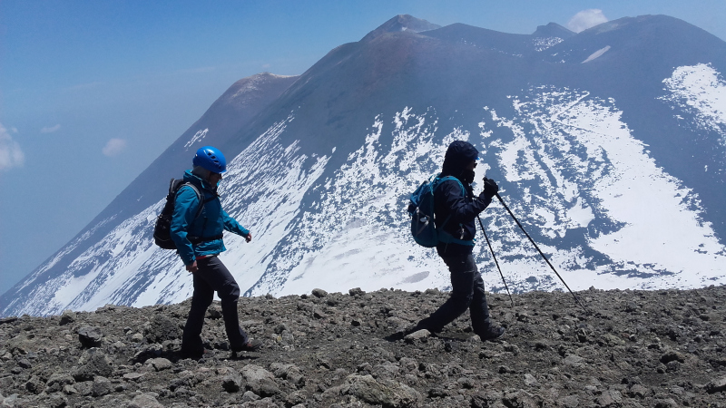
Yes, I know to get to the summit of Mount Etna, you are obliged to hire a guide, but… but… there is a long trail you can follow to do a self-guided hike to the summit of Mount Etna. Above all, remember to be cautious. Mount Etna is a medium explosive volcano but is one of the most active on the planet. So please, once at the summit, do not stand for too long on the edge of the crater. Remember that explosions happen daily. Ideally, you should wear a helmet. Reach Piano Provenzana, the site of the massive eruption of 2002 on Etna north side. From Piano Provenzano, look for a green bar by the office of a hiking company. Now all you have to do, follow the wide trail. Along the way, you can even visit the craters formed during the massive eruption of 2002. After three hours, you will reach a crossroad; the one on the left head towards the observatory of volcanology, while the one that leads straight goes to the summit of mt Etna. Suppose you feel that going to the volcano's summit is too hard, go to the observatory, the view is fantastic, and not everybody comes this far on foot. An alternative might be the rental of two E-Bike at the Clan Dei Ragazzi, a Mountain Chalet not far from Piano Provenzana. We advise you to refrain to climb to the summit between November and late April, the presence of ice can be dangerous.
4 Vendicari Nature reserve
6 km 2 hours level: easy

This self-guided hike is ideal for beach lovers or families with young kids. The Vendicari Nature Reserve is located in the province of Syracuse within the municipality of Noto. Within the reserve, there are three trails; one archaeological, one historical and the blue one, a naturalistic one that winds along the beaches of the reserve. The blue route will allow you to visit the northern area of the reserve, starting from the Eloro beach. After a short walk along the dirt road from the entrance to Eloro, you will find yourself in front of the Eloro beach! On your left are the remains of the Greek city with the same name. First stop - Eloro beach If you started the journey early in the morning, we recommend that you enjoy this beautiful beach! A stop and a swim before leaving are recommended! Second stage - Marianelli beach Cross the Tellaro creek and continue along the path (or by sea), thus arriving at Marianelli, an isolated, wild and unspoiled beach. Enjoy and chill out. Third stage - Calamosche beach It's time to move towards Calamosche ... Climb up from the small rocky gutter to the right of Marianelli beach and walk along the beaten path. After about twenty minutes of walking… Here is Calamosche! A little tiring, but you have been rewarded! In front of you the most famous beach in reserve!
5 The Nebrodi Mountain Range
22/24 km 8/10 hours level: medium

The Nebrodi Mountain Range is the largest nature reserve in Sicily; The peculiarity of this self-guided hike is the presence of lakes, a rarity in Sicily. To reach the beginning of this trail, drive towards the town of Cesarò. Then head for “Portella Femmina Morta” take the paved road towards to the north-east and follow it for about 1.5 km, up to the "Portella Calacudera"; a crossroads where you have to park the car. From Portella Calacudera proceed straight on a dirt road, soon you begin to descend slightly in altitude. You will be inside a beautiful beech forest interrupted by some small clearings from time to time. Pass a stretch of paved road with a very bumpy bottom, and you reach, immediately after a short steep descent, the small Lake Maulazzo. Once you have bypassed the lake from the north - leave a deviation on the left and always follow the signs for the Biviere di Cesarò and Portella Mitta - the road begins to descend again. From here, walk along the dirt road on the left, pass over a stream hidden by the dense beech forest. After a double bend, you meet some centuries-old beech trees and a large clearing. Reached the crossroads of Passo Taverna, leave the road on the left, which proceeds towards Alcara Li Fusi, and continue eastwards, crossing the Cuderì stream. From the road, it goes mainly downhill. The beech forest becomes even more dense and beautiful. You pass another stream - also in this case and in the following ones you have to walk in the water. Further on, along the northern slopes of Monte Soro, you reach a vast clearing and a large pool of water on the north-eastern edge. Back in the woods again, you pass two other small streams and then, in the distance, on the right, you can see the outline of the Casa Riviere. Leaving a detour to the left, take a stretch of road bordered by holly and reach Lake Biviere with a fantastic view of Mount Etna in the distance